Eastern Visayas, also known as Region VIII, is one of the 17 administrative regions of the Philippines.
It is composed of six provinces: Biliran, Eastern Samar, Leyte, Northern Samar, Samar, and Southern Leyte. It also includes the highly urbanized city of Tacloban, which serves as the regional center and the gateway to the region.
Quick Summary:
| Attribute | Value |
|---|---|
| Land Area (2013) | 232.35 km2 (8971 sq mi) |
| Population as of 01 May 2020 | 4,547,150 |
| Regional Center | City of Tacloban |
| Provinces of Region 8 | Biliran, Eastern Samar, Leyte, Northern Samar, Samar, and Southern Leyte |
| Highly urbanized city | City of Tacloban |
| Consists of | 7 cities 136 Municipalities and 4,390 Barangays |
The region occupies the easternmost part of the Visayas, an island group in the central Philippines.
It is surrounded by various bodies of water, such as the Philippine Sea, the Leyte Gulf, the Surigao Strait, the Bohol Sea, the Canigao Channel, the Camotes Sea, the Visayan Sea, the Samar Sea, the Ticao Pass, and the San Bernardino Strait.
The region has a total land area of 23,251.10 square kilometers, which accounts for 7.2% of the country’s total land area. It has a population of 4,547,150 as of 2020, making it the third most populous region in the Visayas.
Also Read: List of Regions in the Philippines
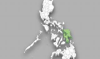
Region 8 Map
Provinces of Region 8
Eastern Visayas comprises six provinces that occupy the easternmost part of the Visayas island group.
These provinces are Biliran, Eastern Samar, Leyte, Northern Samar, Samar, and Southern Leyte. Each province has its own unique history, culture, and attractions that make it worth visiting.
Here is a brief overview of each province:
Biliran:
Biliran is the smallest and newest province in the region, having been created in 1992 from the former sub-province of Leyte.
It is composed of one island, Biliran Island, and several smaller islands. It is known for its natural attractions, such as waterfalls, springs, beaches, and mountains.
Some of the popular tourist spots in Biliran are the Tinago Falls, the Mainit Hot Spring, the Sambawan Island, and Mt. Panamao.
Biliran is also home to the Naval State University, the only state university in the province.
Eastern Samar:
Eastern Samar is the easternmost province in the country, facing the Philippine Sea. It was created in 1965 from the former province of Samar.
It has a rugged terrain, with mountains, valleys, and plains. It is rich in natural resources, such as gold, copper, chromite, and manganese.
It is also known for its historical and cultural heritage, such as the Balangiga Bells, the Homonhon Island, the Guiuan Church, and the Sulangan Shrine.
Eastern Samar is also famous for its surfing spots, such as Calicoan Island, ABCD Beach, and Guintagican Island.
Leyte:
Leyte is the largest and most populous province in the region, occupying the northern half of Leyte Island. It was one of the original provinces of the Philippines, having been established in 1565.
It has a diverse landscape, with mountains, plains, rivers, lakes, and coasts. It is also rich in historical and cultural significance, being the site of the Battle of Leyte Gulf, the largest naval battle in history, and the Leyte Landing, the return of General Douglas MacArthur to the Philippines during World War II.
Some of the notable attractions in Leyte are MacArthur Park, the San Juanico Bridge, the Leyte Provincial Capitol, and the Sto. Niño Shrine and Heritage Museum.
Leyte is also known for its festivals, such as the Pintados Festival, the Sangyaw Festival, and the Buyogan Festival.
Northern Samar
Northern Samar is the northernmost province in the region, occupying the northern part of Samar Island. It was created in 1965 from the former province of Samar.
It has a mountainous terrain, with forests, caves, and waterfalls. It is also endowed with natural resources, such as nickel, iron, and coal.
It is also known for its historical and cultural sites, such as the Capul Island Lighthouse, the Biri Rock Formations, the San Antonio de Padua Church, and the Pinipisakan Falls.
Northern Samar is also famous for its handicrafts, such as the banig, the tikog, and the salakot.
Samar:
Samar is the third largest island in the country and the westernmost province in the region. It was one of the original provinces of the Philippines, having been established in 1649.
It has a rugged terrain, with mountains, plateaus, and valleys. It is also rich in biodiversity, being home to various flora and fauna, such as the Philippine eagle, the tarsier, the orchid, and the molave.
It is also known for its natural wonders, such as the Sohoton Caves and Natural Bridge Park, the Calbiga Caves, the Lulugayan Falls, and the Marabut Marine Park.
Samar is also famous for its literature, being the birthplace of some of the country’s renowned writers, such as Francisco Balagtas, Jose Rizal, and Francisco Sionil Jose.
Southern Leyte:
Southern Leyte is the southernmost province in the region, occupying the southern half of Leyte Island. It was created in 1959 from the former province of Leyte.
It has a hilly terrain, with slopes, ridges, and valleys. It is also rich in marine resources, being part of the Coral Triangle, the global center of marine biodiversity.
It is also known for its historical and cultural landmarks, such as the Limasawa Island, the site of the first mass in the Philippines, the Agas-Agas Bridge, the highest bridge in the country, the Monte Cueva Shrine, and the Maasin Cathedral.
Southern Leyte is also famous for its whale shark watching, diving, and snorkeling activities, especially in the towns of Pintuyan, San Ricardo, and Padre Burgos.
These are the six provinces of Eastern Visayas, each with its own distinct identity and charm. They offer a variety of experiences for travelers who want to discover the beauty and diversity of the region.
Natural Attractions
The region is known for its natural wonders, such as the:
- San Juanico Bridge, the longest bridge in the Philippines that connects the islands of Samar and Leyte;
- the Sohoton Caves and Natural Bridge Park, a protected area that features limestone formations, caves, and a natural bridge;
- the Agas-Agas Bridge, the highest bridge in the country that spans the Sogod River;
- the Capul Island Lighthouse, a historical landmark that guides ships passing through the San Bernardino Strait; and the
- Guiuan Church, a 17th-century church that survived the onslaught of Typhoon Haiyan in 2013.
Language and Ethnic Groups
The region is also rich in cultural heritage, as it is home to various ethnic groups, such as the Waray-Waray, the Cebuano, the Abaknon, the Baybayanon, and the Kinabalian.
The region’s languages, literature, music, dances, festivals, crafts, and cuisine reflect the diversity and creativity of its people.
Some of the region’s notable cultural expressions include the Kuratsa, a traditional courtship dance; the Leyte Kalipayan Dance Company, a folkloric dance troupe; the Buyogan Festival, a religious celebration that features bee-inspired costumes and performances; the Binagol, a sweet delicacy made from taro and coconut; and the Waray literature, a body of oral and written works in the Waray-Waray language.
Eastern Visayas is a region that offers a lot of attractions and experiences for visitors who want to explore its natural beauty and cultural legacy. It is a region that showcases the resilience and vibrancy of the Filipino spirit.